|
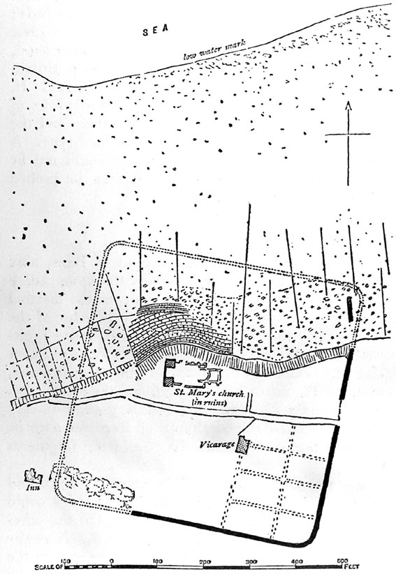
Fig 7 Plan of Roman Fort at
Reculver
(From Arch. Journal lxxxvi, p 299)
as even then endangered, and Battely, who
died in 1708, testifies that in his lifetime the waves were
already devastating the north face of the fort. By 1784, when
Boys made his plan, its north-west angle had wholly vanished,
and very soon afterwards the rest of its northern side perished.
Sea-walls have since saved much, but nearly a third of its area
has been swallowed up. The rate of erosion has probably not been
uniform, and we cannot now determine how far off to the north
the shore lay in Roman times. But we may assume that the fort of
Reculver stood a little way back from the open sea, on some
sheltered inlet or harbour.
The fort itself, when perfect, formed a nearly
square enclosure with rounded angles, measuring internally about
570 ft. by 585 ft., and covering, exclusive of its walls, a
trifle over 7½ acres.21 The walls still stand
in places 8 ft. to 10 ft. high, and must originally have been
more than twice that height. They are in general 8 ft. or 8½
ft. thick, but broaden to 10 ft. at the bottom, owing to two
offsets on the inner side. They consist of a facing — now
mostly gone — of coursed Kentish ‘rag,’ in which the
stones average 5 in. to 6 in. square, a core of flint, tufa, and
sandstone rubble, some of it set slantwise in a common fashion,
and thirdly a slight foundation, about 6 in. in depth,
21
These dimensions are taken from a note and plan contributed by
Boys to Nichols’ Bib1. Topogr. Brit. i, 83—6,
showing the site in 1781, when the north-east angle of the fort
still survived. Boys’ original drawing is in the Soc. of Antiq.
scrapbooks at Burlington House. The Ordnance Survey, followed by
Fox, Arch. Journ. liii, plan, makes them less, 565 ft. by
565 ft. But the north wall must have vanished before the
Ordnance Surveyors measured the site and their dimension must
therefore be conjectural. |