|
Of the rest of the Roman town walls we know
nothing. Various pieces of old masonry, 12 ft.
thick or more, were detected under the modern streets during
the drainage, and many of them have been from time to time
explained as bits of the Roman town wall. But the principal
theory, which concerns Sun and Guildhall Streets, seems to
rest on a total mistake as to what was found beneath them (p.
73), and the remains in general are both too incoherent
to fit into any theory of the |
|

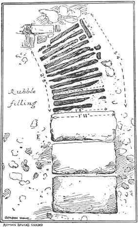
Fig. 13.—Canterbury: Fragment of
Roman Gateway adjoining the Quenin Gate
(From a drawing by Major Gordon Home
in Arch. Journ. lxxxvi, 271)
|
Roman ramparts and too ill-recorded to be
assigned offhand to Roman builders. Nor do the arguments
based, for example, by Faussett on old Canterbury boundaries
yield any satisfactory results. We must in the meantime be
content with the three reasonably fixed points of the Worth,
Riding and Quenin Gates on the east, and the line of the river
on the west. Roman Canterbury, as walled, cannot have been
very different in size from that part of the wailed medieval
town which lay to the east of the Stour—some forty or fifty
acres in extent.
From the walls we pass to the inhabited area
within them. The area in which Roman houses have actually been
found measures roughly some 550 yards from north to
south and 400 yards from east to west. Its limits are, on the
north St. Alphege Lane, on the east Iron Bar Lane and Simon
Langton’s Schools, on the south St. John’s Lane, and on
the west the channel of the Stour which now flows under
King’s Bridge at the end of High Street (plan, Pl. XII). It
has no very definite boundaries, but it seems to have been
largely surrounded by water. |
|
On the west a branch of the Stour still
flows appropriately. On the other sides, deposits of
silt and mud, some of them 130 ft. across, have been found,
one near the north-western or Arundel tower of the Cathedral,
one under Iron Bar Lane and the adjacent parts of Burgate and
the Parade, and one under the eastern part of Watling Street.
These indicate |