|
Fawkham and Ash Archaeological Group
(FAAG)
The discovery
and excavation of a Late Iron-Age and Early Roman Farmstead at
Martin's Quarry, Longfield, Kent 1974 and 1979 TQ6084/6842
Excavation
Overview
Rescue excavations
carried out by members of the Fawkham and Ash Archaeological Group
(FAAG) during October and November 1974 and January to April 1979, led
to the discovery of lengths of boundary ditches, pits and postholes.
These were dated by pottery to the late Iron Age and early Roman
periods, and indicated the presence of a late Iron Age and
Romano-British Farmstead.
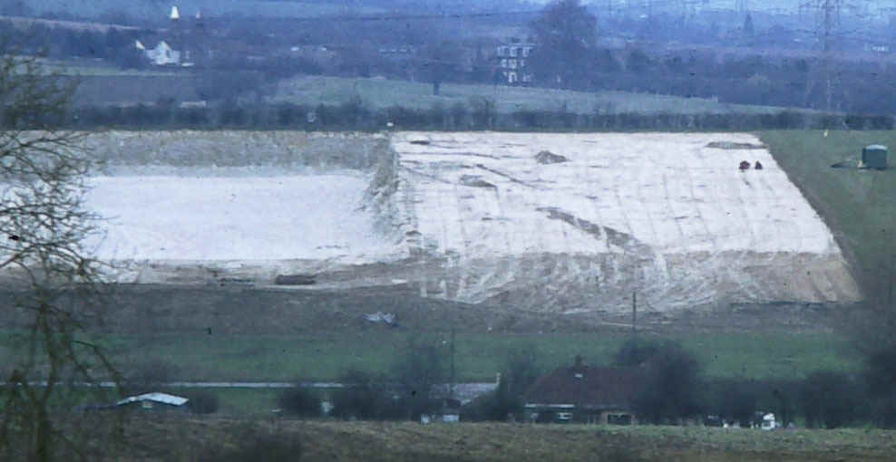
Martins Quarry from the South. 1974 section on
the left, worked out. 1979 section on the right with ditches showing
Ditches
Pits Postholes
In total, 16 lengths of ditches have been excavated and recorded,
some of which contained finds including pottery, daub and bone.
Ditch E (1974)
Ditch E ran for approx 29 metres from west to east across the site. At
its eastern end it turned south for 5 metres and stopped. It was cut
through at this point by Ditch D. Ditch E was 1.00 metre wide and 0.5 metres deep. The filling was black loam with chalk lumps. At the
western end, Ditch E appeared to terminate in a causeway under and
therefore earlier than Ditch D. It was assumed that Ditch J formed the
other side of the entrance.
Ditch E contained pottery and part of a bronze bracelet MQ13. MQ13 was
partially sealed by and therefore earlier than Ditch D and under MQ9.
The extreme end of Ditch E was discovered in 1979 and called JH.
Ditch J (1974)
Ditch J was filled with dark brown loam and many chalk lumps and
contained pottery and animal bone (MQ10). Ditch J was 0.55 metres
deep and 1.1 metres wide and was 3.50 metres long from its terminal
point into the western edge of the excavation. It was assumed that
Ditch J formed the western side of the causeway with Ditch E. The
entrance itself was 3 metres wide.
Ditch D (1974) Ditch ED (1979)
This ditch ran east from the western edge of the quarry for a length
of 45 metres. It was first found in the 1974 excavation and was picked
up again in the 1979 dig, where it was called Ditch ED. At the eastern
edge it turned south for a further 5 metres (Ditch JE) and stopped,
forming a possible entrance. Ditch D cut through Ditch E in two places
(see site plan) and so was later in date. Ditch D was 1.00 metre deep
and 1.00 metre wide. It was filled with black loam and chalk lumps and
contained pottery and animal bone (MQ5) at its western edge. At the
intersection with Ditch E, but within Ditch D were MQ9 and MQ12
containing animal bone and pottery.
In the 1979 excavation of Ditch ED, 4 trenches were dug across the
ditch. Finds included pottery, animal bone and pot boilers (Trench 1 -
MQ41 and 75, Trench 2 – MQ44, 47 and 76, Trench 7 – MQ64 and 72,
Trench 8 – MQ65) and an articulated skull and backbone of possibly a
dog was found in Trench 2 (MQ44).
At the eastern end, Ditch ED turned south for a further 5 metres,
called Ditch JE. It was parallel with the end of earlier Ditch E and
very shallow, barely penetrating into the chalk. The fill of JE was
dark brown clayey loam, with medium and small chalk rubble and a
little broken flint. Two trenches were excavated across JE, Trench 9
(MQ70) and Trench 10 (no finds).
Ditch B (1974)
Ditch B ran from the western edge of the quarry for 15 metres to the
east, becoming narrower and shallower along its length and then
terminating. It was filled with black loam and chalk lumps and
contained pottery and animal bone MQ2. It was 1.00 metre wide and 0.50 metres deep when first appeared after topsoiling by machine, but
much narrower and shallower when properly excavated.
Ditch X (1974) Ditch JB (1979)
Ditch X appeared in the middle of the machine cleared area and like
the other ditches ran across the slope from west to east for a
distance of 10 metres. Close to the eastern limit of the 1974
excavation, the ditch started to turn south south east for 3 metres
before disappearing under the unexcavated part. The fill was brown
loam with chalk lumps and contained some pottery MQ23 and further
south south east MQ11. It was picked up in the 1979 excavation and
continued south for a further 19 metres, now called Ditch JB and
terminated. The fill was brown loam and large chalk pieces (Trench 6 -
MQ61), Trench 13 – Brown slightly clayey loam with mostly chalk
rubble medium, some fragments of flint. MQ79 contained part of the footring of
a Samian bowl. Ditch X cut through Ditch V and so is later
in date than Ditch V (MQ23). Ditch X cut through post hole EE that
formed the south west corner of a possible four post structure. Depth:
Width:
Ditch V (1974)
Ditch V ran for 11 metres to the edge of the excavated area on the
east side of the 1974 excavation. It did not appear in the 1979
excavation so was presumed to end. It was below Ditch X/JB and so
earlier in date. MQ20 was light brown loam and chalk lumps and west of
MQ19. MQ24 was the west end of Ditch V and filled with light brown
loam and chalk lumps. It contained the base of a coarse pot.
Ditch W (1974)
Ditch W appeared as an off shoot of Ditch V and curved south east for
5 metres and then ended. The filling of Ditch W was very brown with
chalk lumps. MQ19 contained 1 sherd and many pot-boilers and was from
the intersection of V and W, whereas the soil in Ditch V appeared to
be very black. At the time it was felt that Ditch W was later than
Ditch V.
Ditch JA (1979)
Ditch JA ran parallel to Ditch JB, 8 metres apart to the east, for a
total length of 27 metres, running north south. Six trenches were
excavated across the ditch. Trench 3 – MQ58 contained dark brown
loam, with large chalk rubble and flints, with pottery and bone – no
daub at all. Trench 4 – MQ59 fill and finds as MQ58. Trench 5 - MQ60
fill and finds as MQ 58 and 59 with some pieces of daub. Trench 12 –
MQ80 very dark brown clayey loam, with some large chalk rubble and
large broken flints, large 5cm pieces of daub which broke up on
excavation. Finds included part of a base, wall and rim of a colour
coated flagon? and slag. Trench 17 – MQ 80 as above. Trench?? At the
extreme south end of Ditch JA. It was very shallow, with some finds
(MQ82).
Ditch JG (1979)
Ditch JG was a large, wide, very shallow feature running north to
south south east some two to three metres wide and interpreted as a
drove way. No finds were recorded.
Ditch JJ (1974)
Ditch JJ was a large V shaped ditch running from the edge of the
quarry in a north east east direction for a total of 29.5 metres. It
finished some 8 metres from the end of the scraped area. The extreme
west end was first noted when the site was visited on the first day.
The extreme west end was revealed by the JCB and some finds were
recovered MQ3. The area to the east after initial scraping left a
large wide spread of soil that was initially thought to be the remains
of a negative lynchet. However, when a section, some 24m from the
western edge of the quarry, was dug across this spread of soil, Ditch
JJ was discovered. Later on in the excavation the quarry owner’s
machine removed this spread of soil revealing the entire length of
Ditch JJ. A number of trenches were excavated across this Ditch, from
2 – 7 metres (MQ31), from 14 –17m (MQ26), from 18-20m (MQ27), from
21-23m (MQ16), and the last area was 24.5 – 29.5m the eastern edge
of the ditch. The upper part of the fill was MQ17 with MQ25 lower
down. During the excavation of this section, it became apparent that
the eastern end of Ditch JJ had cut through a shallow pit on the
southern side approx 2 m wide and two postholes on the northern side
of point each 0.75m wide (MQ29/30). The Ditch was 1.25m deep and 1.50
m wide. It was V shaped with a flat bottom 0.50m wide.
Ditch N (1974 and 1979)
Ditch N commenced 4.50m east of the edge of the quarry, some 4.50
m south of Ditch JJ and ran in a south south east direction for a
further 10.50m where it turned eastwards and ran for a total of 29m to
the edge of the 1974 excavations. It continued into the 1979
excavation for a further 7m (JF) It contained no finds.
Pits
Postholes
In the 1974 excavation, 9 pits were discovered and in 1979 20 more
pits were found.
1974 Excavation
Four "tin bath" rectangular shaped pits were discovered,
pits T and U south and parallel to Ditch JJ and pits L and M north and
parallel to ditch N.
Pit T
Pit T was approx 0.75m deep, and 1.50m wide at the top and 1.05m
wide at the bottom, 2.5m long at the top and 2m at the bottom, i.e.
with steeply sloping sides. Context number MQ14.
Pit U
Pit U was approx 0.45m deep, and 1.20m wide at the top and 1.05m
wide at the bottom, 2.5m long at the top and 2m at the bottom, i.e.
with steeply sloping sides. Context number MQ15.
Pit L
Pit L was approx 0.45m deep, and 1.20m wide at the top and 1.05m wide
at the bottom, 2.5m long at the top and 2m at the bottom, i.e. with
steeply sloping sides. Context number MQ15.
Pit M
Pit M was approx 0.75m deep, and 1.15m wide at the top and 0.75m
wide at the bottom, 2.8m long at the top and 2.5m at the bottom, i.e.
with steeply sloping sides. Context number MQ18.
Pit S
Pit S was 32.5m east of base line, and 96m south of peg A. It was 8m
south east of the eastern end of Ditch JJ. This pit was oval in shape,
1.13m by 1.45m and 0.82m deep. Context numbers MQ8 and MQ22. There
appeared to be a posthole packed with flints at the centre of this
pit. (The drawn section is the only evidence for this conclusion.)
Pit P
Pit P was 32m east of baseline and 108.5m south of peg A. It was
6m south of Ditch N and circular in shape, diameter 0.5m and 0.12m
deep, very shallow with no finds.
Pit R
Pit R was 32.5m east of baseline and 96m south of peg A, 6m north
of Ditch N. It was circular in shape 0.65m in diameter, 0.15m deep.
Pottery (MQ28) was found at the very bottom.
Pit C
Pit C was at the extreme west face abutting the quarry. It was
destroyed by machine on the first day of attendance. 3 sherds of
pottery were retrieved MQ6.
Pit AJ
Pit AJ was 27m east of baseline at the extreme eastern end on the
south edge of Ditch JJ. This feature was only recognised as a separate
pit on completion of the excavation and cleaning up of the eastern end
of Ditch JJ. Maximum length was 2.50m width unknown but at least
0.75m, depth approx 0.40m. This pit had been cut by Ditch JJ during
its construction and therefore was earlier in date. It is not known if
any of the finds from MQ17 came from this feature. (See postholes ?
and ?)
1979 Excavation
Of the twenty pits found and excavated in 1979, the following
contained finds: JD, JC, DZ, EC, EA, EB, EP, EV, FR,HV, GT.
Pit EA
This pit was 81.40m east of the baseline and 12.50m south of peg
A. It was oval in shape, 4.20m by 2m. The depth was ??. MQ43, 48, 52,
and 53.
Although this pit was oval at the surface of the chalk, when fully
excavated the bottom was clearly rectangular in shape. Evidently the
pit had been left open to the elements and frosting and weathering had
caused the sides to collapse inwards.
This pit was the most northern and eastern feature discovered during
the 1979 excavations and the subsequent soil stripping of the entire
rest of the field in 198? when it was feared the Channel Tunnel
railway was coming through that part of the field.
Pit FR
This pit was 81.40m east of the baseline and 12.50m south of peg
A. It was oval in shape, 4.20m by 2m. The depth was ??. MQ57 and 62.
Pit EP
This pit was 68m east of the baseline and 89.70m south of peg A.
It was oval in shape, 4.20m by 2m. The depth was ??. MQ42.
Pit EC
This pit was 45.65m east of the baseline and 44.08m south of peg
A. It was oval in shape, 2.40m by 2.90m. The depth was ??. MQ46, 56,
66, 67, 73, 77 and 81.
Pit EV
Pit EV was 43.36m east of the baseline and 40.54mm south of peg A.
It was roughly circular in shape, pointing east, 1.85m by 1.75m. The
depth was ??. MQ55.
Pit DZ
Pit DZ was 52.84m east of the baseline and 58.03m south of peg A.
It was sub rectangular in shape, 1.60m by 1.40m, pointing north east.
The depth was ??. MQ69 and 74.
Pit EB
Pit EB was 52.84m east of the baseline and 58.03m south of peg A.
It was sub rectangular in shape, 1.60m by 1.40m, pointing north east.
The depth was ??. MQ69 and 74.
Pit JD
Pit JD was 49.06m east of the baseline and 113.38m south of peg A.
It was circular in shape, diameter 1.30m. The depth was ??. MQ71.
Pit JC
Pit JC was 51.54m east of the baseline and 45.89m south of peg A.
It was circular in shape, diameter 1.10m. The depth was 0.05m. MQ63.
Pit EK
Pit EK was 46.20m east of the baseline and 61.70m south of peg A.
It was rectangular in shape, 0.80m by 0.35m, pointing east. The depth
was ??. No finds were recorded.
Pit DE
Pit DE was 50.81m east of the baseline and 48.82m south of peg A.
It was oval in shape, 1.40m by 0.80m, pointing north, north west. The
depth was ??. No finds were recorded.
Pit DB
Pit DB was 50.78m east of the baseline and 50.75m south of peg A.
It was an irregular oval in shape, 1.70m by 1.10m, pointing north
west. The depth was 0.25m. The only find recorded was sandstone.
Pit DF
Pit DF was 51.87m east of the baseline and 48.64m south of peg A.
It was sub rectangular in shape, 1.10m by 0.95m, pointing north north
west. The depth was ??. No finds were recorded.
Pit EX
Pit EX was 48.93m east of the baseline and 44.08m south of peg A.
It was rectangular in shape, 1.10m by 0.70m, pointing north. The depth
was 0.15. No finds were recorded. This may have been natural.
Pit GP
Pit GP was 62m east of the baseline and 60.68m south of peg A. It
was rectangular in shape, 0.30m by 0.10m, pointing north. The depth
was 0.06m. No finds were recorded.
Pit GT
Pit GT was 62.65m east of the baseline and 55.45m south of peg A.
It was sub rectangular in shape, ????m . The depth was 0.60m. Finds
included black pottery and daub, but no context number was allocated.
Pit HV
Pit HV was 71.95m east of the baseline and 52.70m south of peg A.
It was oval in shape, 0.36m wide . The depth was 0.20m. Finds included
pottery and daub, but no context number was allocated.
Pit GU
Pit GU was 64.30m east of the baseline and 57.10m south of peg A. It
was oval in shape, 0.95m by 0.55m wide, pointing west north west. The
depth was 0.10m. There were no finds.
Pit GY
Pit GY was 65.64m east of the baseline and 55.22m south of peg A.
It was oval in shape, 0.90m by 0.60m wide, pointing north east. The
depth was 0.70m. The pit had a sloping side to the north east. There
were no finds.
Pit HU
Pit HU was 72.09m east of the baseline and 54.24m south of peg A.
It was oval in shape, 0.35m by 0.55m wide, pointing north. The depth
was 0.17m. There were no finds.
Pit KE
Pit KE was 57.80m east of the baseline and 88.90m south of peg A.
It was circular in shape, 0.70m wide, and 0.19m deep. The filling was
light brown loam, with chalk lumps and flint and contained 5 vessels
including a cinerary urn.
Postholes
31 postholes were discovered in 1974 and approx 158 were found in
1979. The following postholes from the 1979 excavation had finds: BP
(MQ49), BR (MQ54), BU (MQ50), BV, CM, DL, FY, DM, GE, GA, GM, GV, HD,
HZ (no layer numbers issued).
There were a number of possible four poster structures on the site
(see plan) such as the following from 1974:
BB, DD, EE and FF
QQ, RR, SS and TT,
KK, LL, MM and NN
And seven more from 1979.
In the 1979 excavation there were a number of small stake holes, but
it is difficult to find any particular patterns amongst the postholes
and stake holes. A study of diameters and depths was also unhelpful.
However the majority of the postholes and stake holes were concentrated in the
centre of the 1979 excavated area, to the north and east of Ditch ED.
There is a very roughly circular area with no post or stake holes to
the east of a line between pegs X and X.
Back to
Contents Page
Return
to Fawkham and Ash Archaeological Group (FAAG) Introduction |