|
Aspects of Kentish Local
History
|
Otford & District Archaeological Group (ODAG)
The
Romano-British Cremation Cemetery at Frog Farm, Otford, Kent, in the context
of contemporary funerary practices in South-East England by Clifford P. Ward
1990
Frog Farm Site, Otford
The importance of
the Pilgrims’ Way/North Downs Ridgeway is underlined by Margary
(1965) who commented that ‘this route is certainly one of the most
important prehistoric thoroughfares in the south-east of England,
for it was from the earliest times the main link between the
Continent and that central downland area of Wiltshire which played
such an important part in the settlements of early man in this
island’. The Darent crossing was one of only five river crossings
required between Folkestone, Farnham and Wiltshire. It comprised a
ridgeway and terraceway below the steep escarpment of the chalk
downs, and ‘formed a valuable link between various Roman sites at
the foot of the downs’. Thus, in the absence of any known east-west
Roman road through Kent south of Watling Street, it may be assumed
that the Pilgrims' Way formed a part of the main communications
network of southern Britain.
The geology of Frog Farm is dictated by the river Darent which in
its course to the Thames broke through the chalk North Downs at this
point. Underlying the chalk is a stratum of gault clay forming the
flat floor of the Vale of Holmesdale, while superimposed on this is
the alluvium of the river flood plain, considerably greater in
extent than befits the present water flow. The actual cemetery site
is on a spread of Second Terrace river gravel, and stands at O.D.
220 feet (Dines et al 1969).
At this point the Pilgrims' Way utilises a slight ridge to climb
westwards from the Darent crossing, and the cemetery would have been
visible from all directions. (map.)
Apart from a small group of Roman pots unearthed north-east of
the farm in 1906, and presented to Maidstone Museum (Acc. not
traced.), the first indication of Roman occupation of the area came
in 1927 when a contractor was laying a gas pipe beneath the Pilgrims
Way. A ‘very hard surface’ was encountered, which was identified, on
very dubious grounds, as a Roman road. The fact that the Sevenoaks
Council granted an additional £35 12s 6d to cut a trench through it
gives some indication of its strength and/or extent (G. Ward
c.1930), but unfortunately nothing further is known, despite a
watching brief kept on subsequent holes in the vicinity. Its
massiveness suggests a structure rather than a road, just possibly a
shrine or further mausoleum, or even the elusive villa long-sought
to the west of the river.
At about the same time a burial group, dated to the second
century A.D., was unearthed at Frog Farm, vessels from which are now
deposited in Sevenoaks Museum. (Acc. K1394).
The site of the settlement at Wickham Field, the former Isolation
Hospital, was subjected to trial excavation in the 1920s & 30s when
evidence of a settlement was found (Clarke & Stoyel 1975), and a
series of investigatory trenches was opened there by the
newly-formed Otford & District Historical Society Archaeological
Group (ODAG) in 1965.
At the end of that year, during construction of a shallow
drainage trench for a potato-clamp immediately outside the back
garden of Frog Farmhouse, a group of Roman pots was discovered by
the farmers, and ODAG was invited to investigate. This group was
identified as a cremation burial group (Grave 1), and in another
part of the trench a substantial ragstone wall was noted which
exhibited a 45° corner and was pierced by a somewhat enigmatic flue.
This subsequently proved to be the best-preserved portion of an
octagonal mausoleum (see below).
In view of the shallowness of the grave bottom, about 16 inches
below the surface, there was a strong possibility that any further
disturbance of the site would cause serious damage to any other
artefacts nearby, and, with the encouragement of the Booker family,
the farmers, a decision was taken to excavate the site in order to
rescue any other remains which might have survived, and to endeavour
to trace the angular building which disappeared beneath a manure
heap.
A 10 feet by 10 feet grid was constructed aligned on the adjacent
garden boundary (a gooseberry hedge) and work proceeded over the
next two years. Due to farming needs it was not possible to extend
the grid northwards or westwards apart from in one area (E 6), and
the garden precluded any extension to the south, although the hedge
was curtailed slightly (See Plate 1).
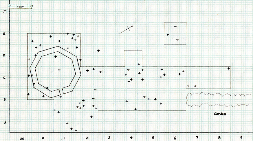
Plate 1. Frog Farm Cremation Cemetery and
Mausoleum - Schematic Plan
Over the area
excavated a series of grave-groups was located immediately beneath
the plough level, mainly in shallow, ill-defined scoops in the
underlying brickearth, and from the damage occurring to all of the
larger vessels, it appeared that the ground surface had been lowered
by up to 1½ feet since the cemetery was in use.
Although no regular pattern of deposition could be ascertained,
unlike the "lines" suggested at e.g. Borough Green (G. Payne 1899)
and other places, the groups were generally spaced at 3-5 feet
between centres, with, in only two instances (Groups 7 & 57),
suggestion of two urns buried together.
The urns had all been placed in holes dug into the gravel
sub-soil, at least three being lined with flints. They were set in
an upright position with ancillary vessels, where present, grouped
round them, having in 8 instances a platter used as a lid to seal
the mouth of the urn. In one case only (Group 18) two fragments of
roof-tile (tegula) had been added to the plate, presumably to
enhance the effect.
The damage to the urns in particular, indicated that they had not
been buried deeply, as many of the vessels had been crushed, with
their rims having fallen on to the bones, leaving the upper portion
of the walls upstanding. In many cases these had been ploughed off
subsequently, rendering complete restoration impossible, but
retaining the most significant identification features i.e. the rim
types together with reasonable indications of the overall size and
character of the vessels. Some of the urns, however, had been
virtually ploughed out, leaving only the base in situ. All were
invaded by grass and other roots, and many were badly distorted.
Some attempt at analysis of the composition of the grave-groups
has been made (Figs
3-9), but there is little indication of strong trends in either
pottery associations or dating in different areas of the cemetery,
although Patchgrove urns preponderate, and of ancillary vessels,
Samian appears to form a higher than usual proportion.
The majority of the samian ware has been identified and dated
from 150-200 A.D. In common with most others the cemetery does not
contain any decorated samian ware, which suggests that it was deemed
unsuitable for funerary purposes. The predominant form is the
platter (Dr 18/31 etc), of which there are 26, with cups (Dr 33
only) numbering 17 (see analyses below).
The piece de resistance came from Grave 45 where a two-handled
samian cup of rare form imitating a metal vessel was placed within a
greyware pie-dish, and had a small samian dish (Dr 36) over it. The
cup was submitted to Dr Grace Simpson who appraised it as Dr 34
having both body and slip of clays containing very fine mica, as
found at Lezoux. The slip is black, through a reduction process in
firing. The vessel is dated A.D. 138-180. Of the original two
handles, one had become detached prior to burial and the scar
appears to have been deliberately smoothed off to some extent, end
it is tempting to think of the cup as perhaps rejected after
accidental damage in a nearby villa, and rescued for use by one of
the local peasants, for whom it became a favourite drinking vessel,
and ultimately accompanied him to the grave.
Towards the north-east, the burials were further apart, shallower
and more fragmentary. It appears that the land surface had been
subject to greater erosion, presumably through ploughing, although
at slightly lower elevation than the mausoleum. The absence of any
remains whatsoever in Grid B6 may indicate the extent of the
cemetery on the eastern side, although no trace of any boundary was
encountered.
In view of impending changes in agricultural operations it was
decided to conclude the excavation by attempting to recover the plan
of the building which until then lay beneath the manure heap. This
was accomplished over the last weekend of April 1968 (plan) and
immediately backfilled. Due to the arrival at that time of the
writer’s baby daughter, the overall appearance of the mausoleum is
known only from photographs (Plates 3, 4 ) and thus some of the
details, e.g. the existence of two small pieces of lead, suggestive
of coffin sheeting of Keston, (not preserved among the finds), said
found in a slight depression at its centre cannot be attested by the
writer.
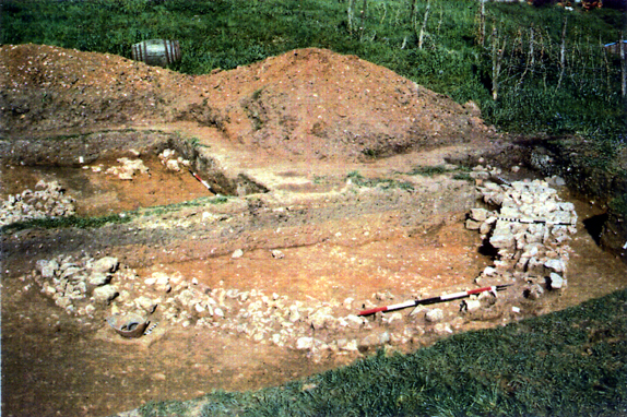
Plate 3. Frog Farm, Otford. Mausoleum from the
south-south-east with entrance on right.
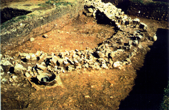
Plate 4. Frog Farm, Otford. Mausoleum from
the west-south-west showing badly robbed
foundations and earlier cremation graves in situ in foreground and to the right.
The structure was
found to be badly robbed over most of its circumference, with only that
portion adjacent to the entrance standing above the foundation which was
composed of 2 courses of flint nodules bedded in gravel 36 inches wide. It
was octagonal in plan with an entrance only 20 inches wide in the centre of
the east-south-east face. Above the flints was one course of neatly-laid
faced ragstone blocks set in
white mortar. These formed walls 34 inches wide. The wall/foundation
did not continue below the entrance, which had been used at some
time, apparently late in the Roman period, as a flue.
The comprehensive robbing had removed all traces of floor and
superstructure beyond a few small opus signinum and tile, both
tegula and imbrex, fragments. No indications of postholes or sleeper
beam slots were noted in the ragstone wall, but the insubstantial
nature of the foundations suggests that the superstructure was
either timber-framed, or, if stone built, limited to one storey.
Nothing can be adduced about the roof, but the few tile remains
point to a tile cladding rather than thatch, and the ragstone for at
least the lower courses of the walls must have been transported a
minimum of two miles from the lower greensand ridge to the South,
suggesting a building aspiring to some degree of ostentation. ODAG's
identification of the structure as a mausoleum was confirmed by the Museum
of London (N.C. Cook pers. discussion).
[NB by adding in the additional groups found in 2006, and the
subsequent Nil groups west of the N-S track to the fields, it should
be possible to make a better guestionmate of the likely size of the
cemetery - perhaps as a Supplement to include the commercial
archaeological contractors work and ODAG's own. We came to the
conclusion we did not want any more, provided they were not under
threat!]
Funerary Practices To Frog Farm Cemetery
contents page Discussion
This website is constructed by
enthusiastic amateurs. Any errors noticed by other researchers will be to
gratefully received
so that we can amend our pages to give as accurate a record as
possible. Please send details too localhistory@tedconnell.org.uk
|